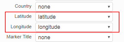
Data can be mapped in EasyMapMaker with only the latitude and longitude. To set the latitude and longitude, make sure the Latitude and Longitude drop downs (see image) are set correctly after clicking “Set Options”. The values need to appear in separate columns.
Drown downs for latitude and longitude
The following formats are supported:
Degrees Minutes Seconds (in the following formats):
- 45° 46′ 52″ N 108° 30′ 14″ W
- 45 46′ 52″ N 108 30′ 14″ W
- N 45 46′ 52″ W 108 30′ 14″
- N45 46′ 52″ W108 30′ 14″
Decimal Minutes (in the following formats):
- 45° 46.8666′ N 108° 30.2333′ W
- 45 46.8666N 108 30.2333W
- variations (with degree sign and spacing) of the above 2 combinations
- N45° 46.8666′ W108° 30.2333′
- N45 46.8666 W108 30.2333
Decimal Degrees ( (in the following formats):
- 45.7811111 -108.5038888 (numerically)
- 45.7811111° N 108.5038888° W
- 45.7811111N 108.5038888W
- variations (with degree sign and spacing) of the above 2 combinations
- N 45.7811111° W 108.5038888°
- N45.7811111 W108.5038888
- variations (with degree sign and spacing) of the above 2 combinations