Heat Maps: View intensity of pins on a map
The heat map layer on Google Maps refers to displaying colors such as red, yellow, and green in order to display the intensity of the number of pins at points on the map .
Google's heat map layer has a variety of options (bold items are changeable on our service) available including :
- dissipating - whether or not the intensity (radius) increases or decreases based on the zoom level. EasyMapMaker does not allow this to be configured, so the intensity changes when zooming in and out
- gradient - the colors used for the heat map. EasyMapMaker does not allow this to be changed, so the default colors: mainly red, yellow and green are used
- max intensity - allows the maximum intensity (color concentration) to be limited instead of based on the number of pins. EasyMapMaker uses the number of pins for the intensity.
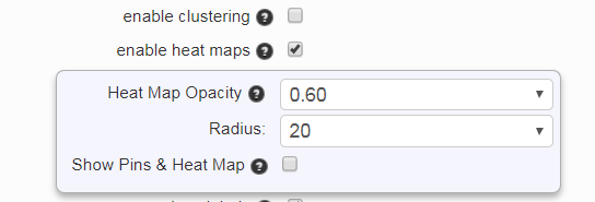
- opacity - the opacity for the heat map layer. The default is 0.60, but EasyMapMaker allows this value to be set anywhere from 0.10 to 0.90 in increments of 0.10
- radius - The radius of influence for each data point, in pixels (per Google). EasyMapMaker allows this value to be set anywhere from 5 to 60. A higher value means the size of the heat layer will be larger for each pin.
Heat Map & Pins
EasyMapMaker has an option to allow the heat map to be shown with the pins. The default is for only the heat map to be shown without pins. When the option is enabled a menu appears below the heat map button (on a map) with the following options:
- Heat Map Only
- Heat Map & Pins
- Heat Map off
To create a map with the heat map layer do the following:
- Drag and drop your file (or copy/paste the data)
- Click Set Options
- Click "enable heat maps"
- (Optional) Change "Heat Map Opacity" or change "Radius"
- (Optional) Enable "Show Pins & Heat Map"
- Generate the map
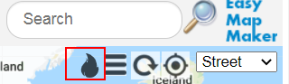
- Click the heat map button in the upper right of the map
Heat Map Options
View Heat Map (click fire icon in upper right)
A good sample map with the heat map layer enabled is the 14,000 zip code map. It shows a lot of zip codes on the east coast of the USA.