Common Questions and their answers (FAQ)
Free version
250 addresses can be added to a map with the free version-
Pro
1,500 addresses can be added to a map with the pro version -
Premium
15,000 addresses can be added to a map with the premium version -
Premium Big Data (no longer available)
100,000 addresses can be added to a map when latitude and longitude coordinates (See Supported formats) are provided.
Add the following parameter to your map: logo=<url>. An example is: https://www.easymapmaker.com/map/58890adb2af63457f31769e607d7501f?logo=//www.easymapmaker.com/cluster_images/semi_opaq/45_blue.png
Another way to add a custom logo is to use advanced map options and upload a logo in the Customization section.
The default image size is 45x45 pixels and the replacement should ideally be the same.
The url must start with either https:// (preferred) or http:// and the url must exist to be included.
EasyMapMaker Subscribers can go to the My Maps menu to view all their maps.
Here is a snippet if you want to quickly make your own solution to get data from a database onto a map:
Google database sample.Mobile/tablet maps are also able to use location services when enabled.
Building and editing maps can be done on mobile and tablet devices, but it is not recommended and not supported.
Assign a group to change the pin colors:
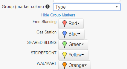
After assigning a group the colors can be changed as shown in the above image.
Free Users
Maps will be remain active unless they have not been modified or viewed in the past 90 days. They can be deleted anytime before this by the person who made the map.Subscription Users
Maps will remain active unless they are deleted by the user or the subscription stops.Pro & Premium Users
Login, view the map and select export map from the menu. A window will popup allowing you to select the options for saving the map. These include poster size images ( Premium only 10800 x 7200) and the visible map window. The image/pdf will use the current zoom level of the map. For images larger than the visible map dimensions, the areas bordering the visible area are used.For high resolution poster sized images, it's a good idea to zoom in. High resolution means the image will be 4 times larger than what is visible in the browser.
Free Users
To save your map as a pdf file, use google chrome or safari to print the map and save it as a pdf file instead of printing it.
You can save your map as an image by taking a screen shot of your map (alt + print screen normally works; or try ctrl + print screen). Once you have a screen shot, you should be able to paste it into an image editing tool such as paint.net. The size of the map can be as large as your web browser window if you don't embed it.You can print the maps under the fair use copyright as long as you include the attribution (in the lower right) and as long as it will not be used in Guidebooks, Consumer Goods (mugs, shirts), or Print advertisement.
For specifics on attribution see google's attribution page.
For more specifics on printing see google's usage in print section.
We use Google's geo-coder to translate an address into a latitude and longitude set of coordinates to be placed on the map.
Sometimes an address is not found and other times it can be placed where it should not be. The geo-coder appears to work very well in most industrialized countries such as the United States. If a location cannot be mapped, sometimes modifying the address slightly will get the address to work. If you only have a zip-code adding a country and state could improving the mapping if it gets placed in the wrong country.
You can manually type in an address to see where Google's geo-coder will place an address .
Be aware that google's geo-coder is not the same as typing something in on Google Maps. Google maps most likely uses google's vast search capabilities to find out where a restaurant, store, address, and other places should be placed on the map.
The accuracy of the geo-coding can be viewed in the EasyMapMaker Accuracy column in the data (emm_acc). The following 4 values can occur:
ROOFTOP
indicates that the returned result is a precise geocode for which we have location information accurate down to street address precision.-
RANGE_INTERPOLATED
indicates that the returned result reflects an approximation (usually on a road) interpolated between two precise points (such as intersections). Interpolated results are generally returned when rooftop geocodes are unavailable for a street address. -
GEOMETRIC_CENTER
indicates that the returned result is the geometric center of a result such as a polyline (for example, a street) or polygon (region). -
APPROXIMATE
indicates that the returned result is approximate.
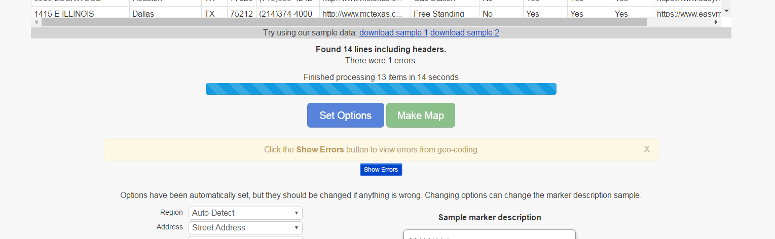
If an address does not have results, the address will be placed in the error table.
On the map creation page the locations that could not be geo-coded show up in an error table as seen in the following images:
Click show Error button to see errors:
Errors in Error table:
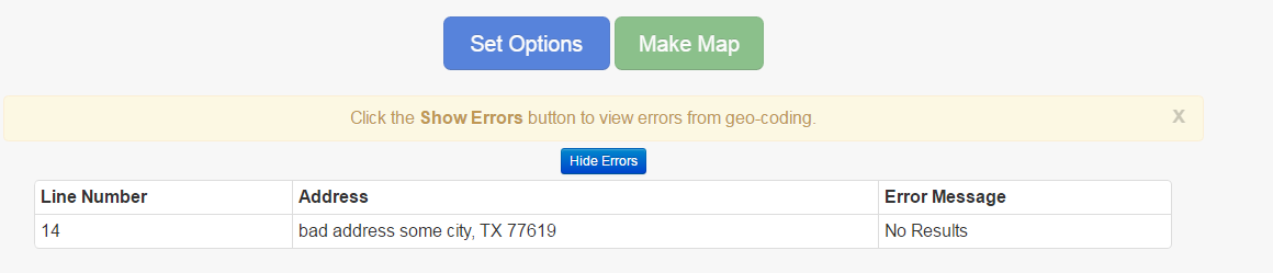
On the Edit page, the original data can be re-inserted and re-mapped. The data that had errors will get reprocessed and the successful data will use the information that was already processed. The locations with errors can be seen using the error table (shown above).
According to google terms:
No mass downloading. You will not use the Service in a manner that gives you or a third party access to mass downloads or bulk feeds of any Content. For example, you are not permitted to offer a batch geocoding service that uses Content contained in the Maps API(s)The following formats are supported:
Degrees Minutes Seconds (in the following formats):
- 45° 46' 52" N 108° 30' 14" W
- 45 46' 52" N 108 30' 14" W
- N 45 46' 52" W 108 30' 14"
- N45 46' 52" W108 30' 14"
Decimal Minutes (in the following formats):
- 45° 46.8666' N 108° 30.2333' W
- 45 46.8666N 108 30.2333W
- variations (with degree sign and spacing) of the above 2 combinations
- N45° 46.8666' W108° 30.2333'
- N45 46.8666 W108 30.2333
Decimal Degrees ( (in the following formats):
- 45.7811111 -108.5038888 (numerically)
- 45.7811111° N 108.5038888° W
- 45.7811111N 108.5038888W
- variations (with degree sign and spacing) of the above 2 combinations
- N 45.7811111° W 108.5038888°
- N45.7811111 W108.5038888
- variations (with degree sign and spacing) of the above 2 combinations